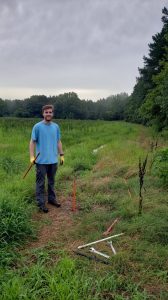
UM geological engineering master’s student Bradley Lewis collects a core sample with a hand coring system. Photo by Ron Counts
A University of Mississippi geological engineering professor and his graduate student are assisting in a federally funded research project to geo-map the United States.
Ron Counts, associate director and research assistant professor in UM’s Mississippi Mineral Resources Institute, and Bradley Lewis, a master’s student in geological engineering from Pearl, began the U.S. Geological Survey EDMAP-funded resource and hazard assessment for Charleston, Mississippi, on June 1.
The project, which ends May 31, 2020, is designed to be an interactive mentoring program between professors and graduate students so the students can gain field experience and skills needed to make geologic maps, while contributing to the USGS efforts to map the geology of the United States.
“The project will map earth materials in the Charleston 7.5 minute quadrangle and will include a preliminary assessment of the upland sand and gravel deposits, which are a heavily utilized resource in the northern part of the state, to see if they may be a viable resource farther south,” Counts said.
Lewis said he became interested in the project following a discussion with Greg Easson, his adviser and MMRI director and professor of geology and geological engineering.
“I enjoy getting to work in the field,” he said. “Dr. Counts had some interesting ideas for the finished products.”
Counts said the work has been enlightening when it comes to understanding the region’s geologic history.
“The sand and gravel deposits are one of the few terrestrial (or nonmarine) deposits in the region from the time period between the Eocene (more than 35 million years ago) and the onset of Pleistocene glaciation (2.4 million years ago),” he said. “Their study has the potential to contribute to research ranging from studies of the evolution of the gulf coastal plain to understanding hydroclimatic and erosional processes (in) the northern U.S. and Canada.”
The duo has found that the town of Charleston may be constructed on an abandoned lake plain that formed during a glacial period when the Mississippi Valley was filled to a much higher level with sediment.
“I’ve found it interesting how multiple geologic processes have come together to create the landforms in the area,” Lewis said. ““Ideally, after finding and analyzing the gravel deposit, there will be enough to economically mine, producing jobs for people in the area. If not, hopefully, the data collected during the project can further research in the future.”
Counts said the data being yielded from the study could have implications for how the ground will shake if there is a major seismic event. The assessment of the sand and gravel could also lead to its development as a local economic resource.