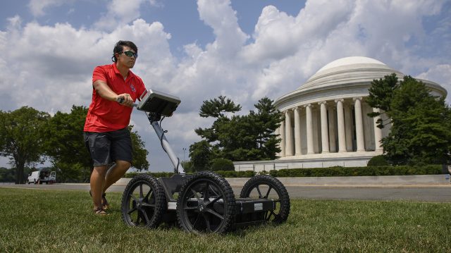
UM geological engineering graduate student Kristian Macias uses a ground-penetrating radar unit to collect data near the Jefferson Memorial in Washington, D.C. Photo by Thomas Graning/Ole Miss Digital Imaging Services
No one foresaw the 2011 earthquake that shook Washington, D.C., but better maps of the structural geological history of the area will help seismologists understand the potential risks.
Researchers and graduate students from the University of Mississippi’s Mississippi Mineral Resources Institute recently spent two weeks in the nation’s capital studying the Adams Mill fault to determine if it continues under several important landmarks.
The team used ground-penetrating radar; refraction microtremor, a method of mapping underground structures by measuring how underground vibrations are bent and reflected by subsurface layers and faults; and electrical resistivity tomography, a technique of collecting information on soil composition, moisture levels and fracture zones by measuring changes in electrical resistance, to image the subsurface at the various field sites throughout downtown Washington.
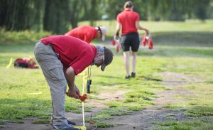
Greg Easson, director of the Mississippi Mineral Resources Institute and a UM professor of geology and geological engineering, helps the research team set up cables for an electrical resistivity tomography analysis at the East Potomac Golf Course. Photo by Thomas Graning/Ole Miss Digital Imaging Services
Greg Easson, MMRI director, said that while the data collection trip to the capital will provide valuable research data, it also provided an opportunity to “get the word out” that UM researchers and students conduct important research.
“Collecting geophysical data on several national park sites, including three days at the Washington Monument, was highly visible and attracted attention,” said Easson, also a professor of geology and geological engineering.
“Data showing the locations and last movements of the geological faults in the D.C. area is important for understanding the geological history of the area, and providing input for a better understanding of the seismic risks in the area. The University of Mississippi is contributing in a meaningful manner to answering these important questions.”
The scientists collected geophysical data and a geochronology sample – one that is collected for analysis to determine the age of the material – on the Smithsonian National Zoological Park grounds, where a Potomac River gravel deposit is faulted by the Adams Mill fault. They also collected geophysical data about four miles to the south in the National Mall and monuments area.
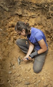
Graduate student Jodi Messick digs for gravel samples at the bottom of a hand-dug hole at the Smithsonian National Zoo in Washington, D.C. The sample is being sent to the U.S. Geological Survey laboratory in Denver for age dating. Photo by Logan Kirkland/Ole Miss Digital Imaging Services
“These areas included the grounds of the Washington Monument, Jefferson Memorial, Lincoln Memorial, Vietnam Veterans Memorial, the JFK Hockey Fields and Potomac Park,” said Ron Counts, principal investigator and science lead on the project.
Kristian Macias, one of two graduate students who worked on the team, said the trip was “a learning experience.”
“Prior to the trip, I had minimal practice with the ERT, seismic and GPR equipment we were using,” the Biloxi native said. “After the first few days, we practically became experts with the equipment.”
The team managed to process some of the data early in the collection process – with staggering results.
“The clarity of some of the imaging was so good, it was literally jaw-dropping,” said Counts, MMRI associate director and adjunct professor of geology and geological engineering. “We are only just now starting to process and interpret our data, but preliminary results show that we were able to obtain some great data that appears to image the geological subsurface.”
The primary goals of the project were to collect data that characterizes what lies beneath the surface and see if the fault’s location could be determined, and to test whether these geophysical methods could successfully reveal what lies underground in an urban environment.
In addition to collecting geophysical data, another project goal was to collect a sample of the gravel that was faulted at the zoo, by the Adams Mill fault, to confirm the preliminary age of approximately 450,000 years that was obtained from a single sample three years ago.
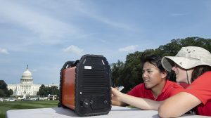
Graduate students Kristian Macias (left) and Jodi Messick check out their electrical resistivity tomography device near the U.S. Capitol. Photo by Logan Kirkland/Ole Miss Digital Imaging Services
“We spent the better part of two days hand-digging a 6-foot-deep hole on the zoo grounds to get a sample from a gravel that had some cobbles as big as footballs,” Counts said. “The sample will be sent to the U.S. Geological Survey laboratory in Denver, Colorado, for age dating using optically stimulated luminescence dating.”
The team also used the ground-penetrating radar to collect data in Constitution Gardens as a favor to the National Park Service. Park Service planners need the data to understand the subsurface in and around the garden as they plan renovation work on a pond.
With field work completed, the group is processing and interpreting the data with hopes of better understanding the long-term geologic history and seismic risks for the area.
“Conclusions thus far are that some of the techniques we used can work very well in a highly urbanized environment, and electrical resistivity imaging does particularly well at imaging faults on the Atlantic Coastal Plain,” Counts said.
“We expect that the analysis of all of the data will take approximately four to six months. Then we will need to synthesize the data and prepare manuscripts for publication.”
The project is funded by the U.S. Geological Survey under Award No. G20AP00098. This data collection effort has been permitted by the National Park Service, Permit No. NAMA-2021-SCI-0002. All the data collection was noninvasive and nondestructive and presented no danger to the monuments or the public.
Click here for a longer version of this story, published by Ole Miss News on Sept. 23.