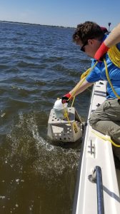
Jarett Barnett, a UM geology and geological engineering graduate assistant, retrieves sensory landers from the Mississippi Sound as part of a study being conducted. Submitted photo
OXFORD, Miss. – University of Mississippi scientists who are studying the Mississippi River’s ebbs and flows are trying to find out how changing water levels in the river can affect fishing and seafood industries in Mississippi.
With the rising water levels in the lower Mississippi River, the U.S. Army Corps of Engineers opened the Bonnet Carré Spillway west of Lake Pontchartrain in early March. As the flooding continued, more bays of the spillway were opened and remained open through the month. The spillway is designed to channel water into Lake Pontchartrain and through the Rigolets Pass into Lake Borgne and ultimately into the Mississippi Sound.
“The opening of the spillway lowers the water levels flowing through the New Orleans area and lessens the pressure on the levees, pumps and other flood control structures,” said Greg Easson, UM director of the Mississippi Mineral Resources Institute, professor of geology and geological engineering, and a co-principal investigator on the study. “As part of the Mississippi Based RESTORE Act Center of Excellence, we are supporting the redevelopment and restoration of the Mississippi oyster resources as a key action in the restoration of the Gulf Coast.
“Understanding the impact of the opening of the spillway on the water properties in the Mississippi Sound is an important component.”
Easson and Jarett Bell, a UM geological engineering graduate student from Bay St. Louis, have been collaborating on the project since before the student graduated from the university with his undergraduate degree last spring. Sensors are used to gather data about dissolved oxygen, conductivity, temperature and light from the water. Bell’s responsibilities include preparing, launching and recovering the sensor programs, offloading and interpreting the data.
“Another preparation is that we use hidden buoys so that our platforms stay out of sight for at least a week,” Bell said. “Once the buoys sit for the allotted time, we retrieve the landers, offload the data, return them back to Oxford and clean all the components.”
Preliminary graphs of dissolved oxygen and conductivity show the influence of a large freshwater influx and subsequent recovery.
“This information generated will have significant implications for oyster reef restoration and resilience on the Mississippi Gulf Coast,” Easson said. “It will provide critical knowledge related to acceptable sites for future oyster reefs that will support sustainable and productive oyster fisheries.”
The results of the study will be shared with MBRACE partners from Mississippi State University, the University of Southern Mississippi and Jackson State University. It will also be the subject of Bell’s master’s thesis in 2019, and an eventual journal article.
This project was paid for [in part] with federal funding provided through the University of Southern Mississippi under the Mississippi Department of Environmental Quality by the Department of the Treasury under the Resources and Ecosystems Sustainability, Tourist Opportunities, and Revived Economies of the Gulf Coast States Act of 2012 (RESTORE Act). The statements, findings, conclusions and recommendations are those of the author(s) and do not necessarily reflect the views of the University of Southern Mississippi, the Mississippi Department of Environmental Quality or the Department of the Treasury.