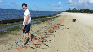
OXFORD, Miss. – As summer heat drives many people to the beach in search of fun in or near the water, University of Mississippi researchers recently went to Pascagoula Beach to conduct measurements designed to help develop systems to detect buried improvised explosive devices – known as IEDs – around the world.
Scientists from UM’s National Center for Physical Acoustics are measuring the Rayleigh wave properties of the ground at several geographical locations, covering a spectrum of soils types. The beach site in Pascagoula was selected as one of the sites being representative of a beach environment.
“A Rayleigh wave is a type of seismic wave that propagates very close to the ground surface and depends on the mechanical behavior of the soil,” said Craig Hickey, interim associate director of applied research and senior research scientist at NCPA. “The goal is to obtain some general knowledge about the behavior of the Rayleigh wave; for instance, how fast and how far it travels and in different types of grounds.”
The U.S. military face dangers and delays from mines and IEDs buried and hidden on- and off-route. To mitigate these dangers, the military is developing technology to detect explosive hazards so they can be avoided or cleared to allow safe passage of personnel, equipment and supplies, U.S. Navy officials said.
Results of the measurements may eventually lead to the creation of devices that can detect IEDs in various types of soil, they added.
Rayleigh waves are produced by earthquakes, auto traffic or simply by hitting the ground with a sledgehammer. The ground returns to its original state after the Rayleigh wave passes, resulting in no permanent deformation.
“It is frequently used by near-surface geophysicists and engineers for nondestructive characterization of building sites for earthquake hazards, searching for groundwater, measuring depth to bedrock, strength of near-surface materials and so forth,” Hickey said.
All measurements performed at the site were nondestructive. All tools were man-portable and required a small portable generator to power the electronic equipment. Measurements performed included:
- Seismic wave measurement: This measurement consists of generating low-amplitude vibrations in the ground using a small mechanical shaker (weighs about 50 pounds) and recording these vibrations at various distances from the shaker source using a track-mounted system.
- Traditional hammer source refraction measurement: This measurement involves generating low-amplitude vibrations in the ground by hitting a metal plate with a sledgehammer and recording these vibrations at various distances, using an array of sensors called geophones. The recorded vibrations are used to determine the speed of the Rayleigh wave and how it attenuates with distance.
- Acoustic measurement: This measurement involves generating low-amplitude vibrations in the ground using the sound from a loudspeaker and recording the sound and ground vibrations at various distances using a microphone and geophone.
- Traditional soil characterization measurements: Field shear vane, cone penetration and soil water tension. These measurements require inserting probes less than an inch in diameter to various depths to a maximum of three feet. In a sandy environment, the residual hole will fill in immediately after the probes are removed.
- Soil sample to be analyzed in the lab.
The U.S. Navy is interested in the ground properties of different environments to better understand the impact on various operations.
For more information about the National Center for Physical Acoustics, visit http://ncpa.olemiss.edu/
